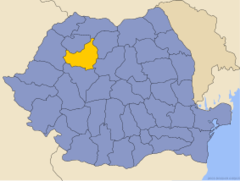
Wilayah Cluj
Wilayah Cluj merupakan sebuah wilayah di Romania yang memiliki luas wilayah 6,674 km² dan populasi 702,755 orang (2002). Ibu kotanya ialah Cluj-Napoca.
Cluj | |
|---|---|
County (Judeţ) | |
 Păniceni wooden church | |
 Cluj county, territorial location | |
| Country | |
| Wilayah pembangunan | Nord-Vest |
| Wilayah bersejarah | Transylvania |
| Ibu kota | Cluj-Napoca |
| Pentadbiran | |
| • Jenis | County Council |
| • President of the County Council | Horea Uioreanu (USL (PNL)) |
| • Prefect2 | Gheorghe Vușcan |
| Keluasan | |
| • County (Judeţ) | 6,674 km2 (2,577 batu persegi) |
| • Pemeringkatan | 12th in Romania |
| Aras | 1,842–227 m (6,043–745 ft) |
| Penduduk (2011) | |
| • County (Judeţ) | 659,370 |
| • Pemeringkatan | 4th in Romania |
| • Kepadatan | 99/km2 (260/batu persegi) |
| • Bandar | 434,201 (66%) |
| Zon waktu | UTC+2 (EET) |
| • Musim panas (DST) | UTC+3 (EEST) |
| Postal Code | 40wxyz3 |
| Kod kawasan | +40 x644 |
| Car Plates | CJ5 |
| GDP | US$ 7.65 billion (2008) |
| GDP/capita | US$ 11,177 (2008) |
| Laman sesawang | County Board County Prefecture |
| 2 as of 2007, the Prefect is not a politician, but a public functionary. He (or she) is not allowed to be a member of a political party, and is banned to have any political activity in the first six months after the resignation (or exclusion) from the public functionary corps 3w, x, y, and z are digits that indicate the city, the street, part of the street, or even the building of the address 4x is a digit indicating the operator: 2 for the former national operator, Romtelecom, and 3 for the other ground telephone networks 5used on both the plates of the vehicles that operate only in the county limits (like utility vehicles, ATVs, etc.), and the ones used outside the county | |

Pendidikan
suntingPembahagian pentadbiran
suntingWilayah Cluj mempunyai 5 kawasan perbandaran, 1 bandar dan 75 komun.
- Kawasan perbandaran
- Câmpia Turzii
- Cluj-Napoca – ibu kota; 309,136 (pada tahun 2011)
- Dej
- Gherla
- Turda
- Bandar
Rujukan
sunting| Wikimedia Commons mempunyai media berkaitan Wilayah Cluj |
Pautan luar
sunting- (Romania) Cluj County map
- (Romania) (Hungary) Administrative map of the county Diarkibkan 2007-08-08 di Wayback Machine
