Fail:Haram-al-sharif-plan-1890.jpg

Fail asli (909 × 847 piksel, saiz fail: 135 KB, jenis MIME: image/jpeg)

Fail ini dari Wikimedia Commons dan mungkin digunakan oleh projek lain. Penerangan pada laman penerangan failnya di sana ditunjukkan di bawah.

Ringkasan

Keterangan
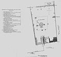
English: A plan of the Haram al-Sharif in 1890, from Palestine Under the Muslims: A Description of Syria and the Holy Land from AD 650 to 1500 (higher-quality images in the link), by Guy Le Strange, London, 1890.
Tarikh (hence out of copyright)
Sumber Palestine Under the Muslims: A Description of Syria and the Holy Land from AD 650 to 1500
Pengarang Mustafaa at Inggeris Wikipedia

Perlesenan

This is a faithful photographic reproduction of a two-dimensional, public domain work of art. The work of art itself is in the public domain for the following reason:
Public domain

Karya ini berada dalam domain awam di negara-negara dengan tempoh hak cipta hayat pencipta ditambah 70 tahun atau kurang.


You must also include a United States public domain tag to indicate why this work is in the public domain in the United States.
The official position taken by the Wikimedia Foundation is that "faithful reproductions of two-dimensional public domain works of art are public domain".
This photographic reproduction is therefore also considered to be in the public domain in the United States. In other jurisdictions, re-use of this content may be restricted; see Reuse of PD-Art photographs for details.

Log muat naik asal

The original description page was here. All following user names refer to en.wikipedia.
  • 2004-11-17 00:14 Mustafaa 1228×550× (75068 bytes) A plan of the Haram al-Sharif in 1890, from ''Palestine Under the Muslims: A Description of Syria and the Holy Land from AD 650 to 1500'', by Guy Le Strange, London 1890 (hence out of copyright)

Captions

Add a one-line explanation of what this file represents

Items portrayed in this file

menggambarkan

media type Inggeris

image/jpeg

Sejarah fail

Klik pada tarikh/waktu untuk melihat rupa fail tersebut pada waktu itu.

Tarikh/WaktuGambar kenitUkuranPenggunaKomen
semasa14:04, 22 Disember 2015Gambar kenit bagi versi pada 14:04, 22 Disember 2015909 × 847 (135 KB)OlevyEmpty zone suppression
13:39, 22 Disember 2015Gambar kenit bagi versi pada 13:39, 22 Disember 20151,228 × 847 (141 KB)OlevyBetter quality picture with reference and maps having the sme orientation
18:41, 9 September 2011Gambar kenit bagi versi pada 18:41, 9 September 20111,228 × 550 (73 KB)MGA73bot2 {{BotMoveToCommons|en.wikipedia|year={{subst:CURRENTYEAR}}|month={{subst:CURRENTMONTHNAME}}|day={{subst:CURRENTDAY}}}} {{Information |Description={{en|A plan of the Haram al-Sharif in 1890, from ''Palestine Under the Muslims: A Description of Syria and

Laman berikut menggunakan fail ini:

Penggunaan fail sejagat