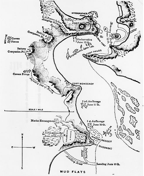
Fail:Corea-map.jpg

Saiz pralihat ini: 492 × 599 piksel. Leraian-leraian lain: 197 × 240 piksel | 394 × 480 piksel | 630 × 768 piksel | 840 × 1,024 piksel | 1,681 × 2,048 piksel | 4,620 × 5,629 piksel.
Fail asli (4,620 × 5,629 piksel, saiz fail: 10.24 MB, jenis MIME: image/jpeg)
Sejarah fail
Klik pada tarikh/waktu untuk melihat rupa fail tersebut pada waktu itu.
| Tarikh/Waktu | Gambar kenit | Ukuran | Pengguna | Komen | |
|---|---|---|---|---|---|
| semasa | 21:54, 20 Januari 2015 |  | 4,620 × 5,629 (10.24 MB) | KMJKWhite | Higher resolution. Obtained from USMC Historical Division Photo archives and converted .tiff to .jpg. https://www.mcu.usmc.mil/historydivision/Korea%201871/Forms/DispForm.aspx?ID=7&Source=https%3A%2F%2Fwww%2Emcu%2Eusmc%2Emil%2Fhistorydivision%2FKorea%... |
| 07:43, 23 Mei 2014 |  | 600 × 773 (99 KB) | FastilyClone | from w:File:Corea-map.jpg (CM) |
Penggunaan fail
Laman berikut menggunakan fail ini:
Penggunaan fail sejagat
Fail ini digunakan oleh wiki-wiki lain yang berikut:
- Penggunaan di ar.wikipedia.org
- Penggunaan di en.wikipedia.org
- Penggunaan di es.wikipedia.org
- Penggunaan di it.wikipedia.org
- Penggunaan di ko.wikipedia.org
- Penggunaan di pt.wikipedia.org
- Penggunaan di ru.wikipedia.org
- Penggunaan di vi.wikipedia.org
- Penggunaan di www.wikidata.org
